NC500 – Civil Engineering Past and Present!
Over the past few years, the North Coast 500 has attracted tourists from all over the world to explore the North of Scotland for many reasons. Whether it’s the scenery, wildlife or history – there’s something for everyone!
One thing that is often overlooked when travelling the North of Scotland is the amazing feats of engineering at your fingertips. The Institution of Civil Engineers (ICE), is the world’s first professional engineering body and keen to stay as current now as they were when founded in 1818, exactly 200 years ago. In collaboration with the NC500, they hope to bring Engineering History to life on your journey in this Bi-centennial year (ICE200). Find out what you can visit on your NC500 travels below..
Speaking with Alasdair Couttie at the ICE, he described how the Institution was formed: “We started our meetings in coffee shops discussing new and interesting achievements in Engineering and Civil, because most engineers at that time were in the military. It took two years to attract the ICE’s first President, Thomas Telford. His appointment in 1820 not only gave ICE a major boost, it also played a huge part in shaping who we are today. Much of the history described here is as a result of this remarkable man. If you ever wonder exactly what a Civil Engineer does take a look at our 10 projects mentioned here and that will answer some of the question. The reality is that we do much more!”

Kessock Bridge
The Kessock Bridge is a cable-stayed bridge which carries the A9 over the Beauly Firth, and inlet of the Moray Firth. Opened in 1982, the bridge replaced the ferry which operated across the tidal Beauly Firth between Inverness and North Kessock, and the jetties can still be seen to the west of the bridge. The bridge lies over the Great Glen Geological Fault and as such is fitted with seismic buffers at the north end of the bridge. The bridge was designed by Hellmut Homberg of Germany and constructed by Cleveland Bridge. The clearance between the water and the underside of the bridge is sufficient to allow ships to enter Inverness Harbour and on to the Caledonian Canal.
The four towers dominate the skyline and are lit at night. Laybys exist at the north end of the bridge which allow sightseers to park their vehicles and walk along the footway on to the bridge to experience the view to the mountains on the west and the outline of Fort George to the east and on occasions the porpoises which visit the Firth. A liquid solution anti-freeze is used on the bridge for winter maintenance, rather than salt, to prevent corrosion of the steel.
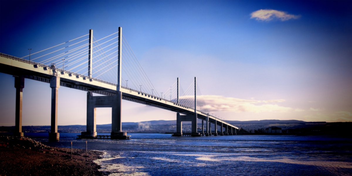
Kessock Bridge, Inverness (c) George Maciver (Adobe Stock)
Mound
The Mound bridge on the A9, was built as part of the 1803 Parliamentary Commission’s plans to build or improve roads in the Highlands. Thomas Telford was given the task of designing the bridge across Loch Fleet, however, one of the aspects he had to overcome, was the fact that the bridge was over tidal water and there was the need to create a reclaimed area inland of the bridge. This he did by creating initially 4 sluice gates into the bridge, which was later increased to 6. These sluice gates were designed to prevent sea water entering the reclaimed area, but at low water, allowed the water from the reclaimed area to drain out to sea. Normally these sluice gates operated automatically, but in flood conditions, winches attached to the sluice gates, which were operated manually, to allow excess water to drain out to sea. These winches were replaced in 2004, one of which was gifted to Dornoch Museum.
The original bridge also replaced the ferry farther out in the Firth. In the mid 1980’s the A9 was re-aligned and a new bridge was built over part of the original Telford Bridge, with the remainder now forming a lay-by to the landward side of the A9, where visitors can stop to view the scenery, including salmon on their way upstream to spawn. The original bridge also carried a light railway between Dornoch and a station on the mainline to the north of the bridge. This line in now closed and no evidence of it exists.
Kylesku Bridge

Kylesku Bridge by Steven Gourlay Photography Ltd
Kylseku Bridge, carrying the A894, was opened in 1984 and replaced the ferry which saved a long detour to get to the other side of the Kyle. One of the old ferries can be seen abandoned on the north shore. The bridge was designed by Ove Arup and Partners and constructed by Morrison Construction Ltd. The bridge is of 3 spans, with the middle span being pre-cast onshore and floated out to a point under the bridge and raised up. This task was made more difficult with the bridge being designed on a curve. Despite some adverse weather conditions during construction, the bridge was completed within the contract period. The clearance from water with strong tidal currents to the underside of the bridge is 400ft (122m).
Glascarnoch Reservoir

Loch Glascarnoch (c) Babetts Bildergalerie (Adobe Stock)
Glascarnoch Reservoir lies along 4.4 miles of the A835 and is part of the Conon Hydro scheme. This dam is from the second phase of development, which included two dams and two power stations. Glascarnoch dam receives water from the two other dams at Loch Droma again visible from the A835 and Loch Vaich and provides flow regulation and storage capacity for Mossford power station to which water flows through a 8km tunnel through the hillside. The inlet for which is upstream of the dam on the southern banks of Loch Glascarnoch. The dam is composed of two flanking turfed earth filled embankment sections with concrete cores and a concrete gravity section and is a dominant in the landscape situated at the top of a small rise and towering over the Aultguish Inn which lies beneath it. The culverts built to pass water through the dam during construction, have been infilled with concrete. They are located beside the scour at the base of the dam. See if you can find them.
Wick and its environs

Thomas Telford, John Rennie, Joseph Mitchell and James Bremner were all involved in various stages with the development of Wick and its Environs. Thomas Telford is attributed with the building of an area of Wick known as Pultneytown, which was constructed to house the people being evicted from the hinterland during the Highland Clearances. The bridge over the river, which replaced a rudimentary footbridge, the only way of crossing the river at that time, is also attributed to Telford. The four engineers were all involved in the design and construction of Wick Harbour and the Breakwater, much of which is still in evidence today.
Kishorn Yard

The former Oilrig fabrication yard lies just off the road from Applecross to Lochcarron at the southern end of the Bealach na Ba (Pass of the Cattle) and consists of a drydock, which was used to construct in 1978, the 600,000 tonne Ninian Central Platform, which was then towed out to its final location in the North Sea. This platform is the largest moveable structure built by man. It was closed in 1987 when all buildings were removed from site.
Recently, life is now being breathed into site, with proposals to create a renewable energy construction hub, resulting in work to bring the drydock gate back into operation. One of the challenges when the site was operating and is likely to be the case with the new venture, is the transport of materials to the site. During the original operation, the site was serviced by sea, as the road infrastructure was not compatible with the type of vehicle carrying materials requiring on the site.
Parliamentary Churches

Kinlochbervie Church
In 1823, Commissioners were set up to erect churches in the most thinly populated areas of the Highlands. Thomas Telford was commissioned to provide plans and specifications for these churches and manses for a cost of no more than £1500 per site. Having considered the task in hand, he settled on an identical design for each one. and you’ll find several of these churches and manses on the NC500. Kinlochluichart, Keiss and Kinlochbervie are still operating as churches, whilst Strathy Church is now converted into a dwelling house. At Poolewe, Stoer and Berridale Churches, only the manses are still standing, and Ullapool Church has been converted into Ullapool Museum. Shieldaig is no longer evident.
Stoer Lighthouse

Stoer Lighthouse by Steven Gourlay Photography Ltd
Stoer Lighthouse is one of the many constructed by David and Thomas Stevenson in 1870. The lighthouse is of squat design, but its location on a clifftop, allows its beam to be observed by ships at 24 miles, from the lighthouse. It is popular with visitors, with approximately 100,000 visiting the lighthouse each year, necessitating the erection of public toilets and the two lighthouse keepers’ cottages becoming holiday homes. The lighthouse was automated in 1978. Being sited in a remote area, this necessitated the lighthouse keepers to have some element of self-sufficiency, and this is evident by the presence of the remains of what can be classed as a croft infrastructure.
Dounreay Nuclear Establishment
Work began on the construction of Dounreay Nuclear Establishment in May 1955 with the construction of two reactors, the first coming into operation in November 1958 and used to test the performance of the materials used in the construction of the fast neutron reactor core, and the second in 1959. It was not until 1962 that power from the second reactor was transferred to the National Grid, continuing until 1977, when the reactor was taken offline for decommissioning. Between 1962 and 1977 it produced over 600 million kWh of electricity. A third and final reactor, being a Prototype Fast Reactor was built on the site. This reactor was cooled by liquid sodium. It started supplying power to the grid in 1975 and continued until 1994 when it was taken offline. In 1998, the UKAEA announced an accelerated timetable for decommissioning from 100 years to 60 years. In 2005 the Nuclear Decommissioning Authority took over the site with the aim of creating a brownfield site by the year 2336.
Caledonian Canal

Neptune’s Staircase (c) Scottish Canals
The Caledonian Canal is perhaps Thomas Telford’s greatest work in the Highlands. Stretching 60 miles along the Great Glen Faultline, from the Beauly Firth at Inverness on the east coast to Loch Linnhe at Corpach on the west coast, the canal links Loch Dochfour, Loch Ness, Loch Oich and Loch Lochy on the way. There are 29 locks throughout the length of the canal, with the most famous being Neptune’s Staircase at Banavie at the western end, which consists of a dramatic flight of 8 locks.
The concept of the canal was to provide employment at the time of the Highland Clearances and to create a short cut for naval vessels travelling from the west coast to the east coast and vice versa, during the Napoleonic War. However, by the time the canal opened in 1822, Napoleon had been beaten at Waterloo, resulting the Royal Navy not needing to use the canal. Remedial work was carried out at the southern end between 1843 and 1847. Since then the canal has been used extensively by commercial traffic, particularly our North-east coast fishing fleet, when it was many times larger than it is today, to prevent the long journey through the stormy Pentland Firth. In recent years much of the traffic has been pleasure craft with local companies renting out pleasure craft to people wishing to take a holiday in a boat on the canal, or companies providing day cruises on the canal.